
 BBC
BBCIn just two weeks, Syrian rebels overran their enclave in the northwest to seize a series of major cities, before reaching the capital, Damascus, and ousting President Bashar al-Assad 13 years after the start of the country's civil war.
In convoys of small vehicles and motorcycles, fighters led by the Hay'at Tahrir al-Sham rebel group moved quickly along the north-south highway that forms the country's main spine to seize Damascus without resistance.
But while many in the country are celebrating the fall of a family dynasty that ruled Syria with an iron fist, the future is uncertain, and the situation on the ground remains in flux, with a number of different rebel groups controlling different parts of the country.
Who controls which region in Syria?
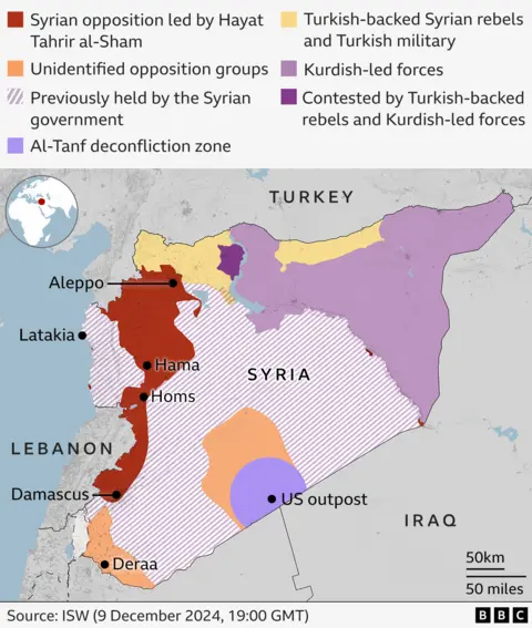
The fall of the Assad regime was brought about by the sudden and unexpected advance of Hay'at Tahrir al-Sham rebels, but although the group controls major cities in Syria, it does not rule the entire country.
Syria has been under the control of a patchwork of rebel groups for years, including Hay'at Tahrir al-Sham in Idlib and Kurdish-led groups in the country's northeast, some of which have also seized territory in recent days and weeks.
None of the rebel groups will mourn the fall of the Assad regime, but reaching a consensus on how to run the country could be difficult, and in the north of the country there have been clashes between rival factions.
How did the rebels reach Damascus?
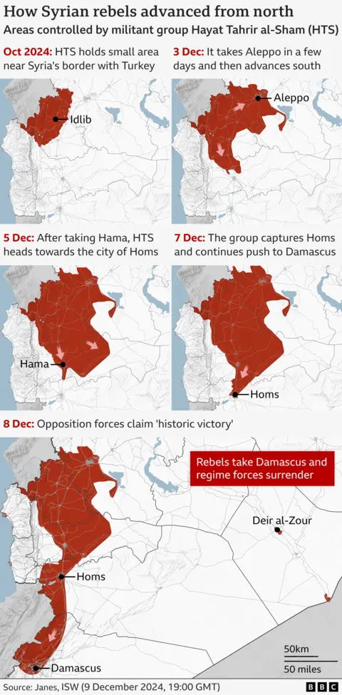
After years of remaining behind frozen front lines, the rebels made lightning advances, culminating in the overthrow of the president and the capture of the capital over the weekend.
After seizing Aleppo, the second largest city in Syria, at the end of November, the rebels continued their attack, moving south to take control of the city of Hama last Thursday.
The advance continued at a rapid pace, with Homs, Syria's third largest city, falling on Saturday shortly before government forces lost control of the capital.
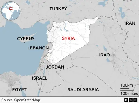
Map: Where is Syria located and how do its neighbors intervene?
Syria, with a population of about 22 million people, is located on the eastern coast of the Mediterranean Sea. It is bordered by Türkiye to the north, Lebanon and Israel to the west and southwest, Iraq to the east, and Jordan to the south.
Türkiye, Western powers, and several Gulf Arab states supported various elements of the Syrian opposition to varying degrees during the conflict.
The Lebanon-based, Iranian-backed Hezbollah movement fought alongside the Syrian regime's army, but has been severely weakened by its conflict with Israel. This is seen as the main reason behind the success of the rebel advance.
Israel, concerned about what it calls Iranian “military penetration” in Syria, launched air strikes against the Syrian army.
How did Israel respond?
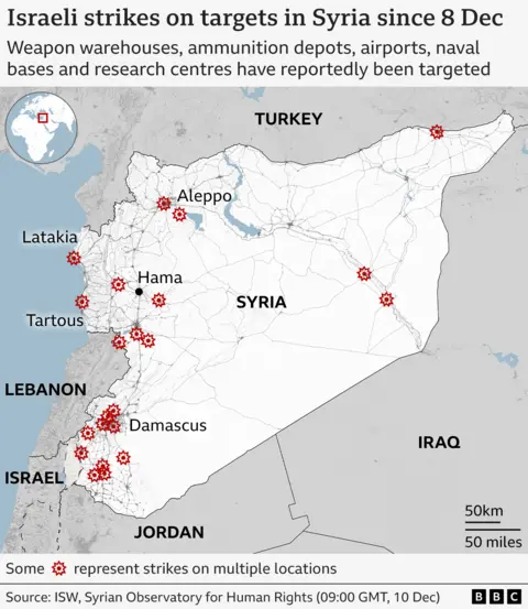
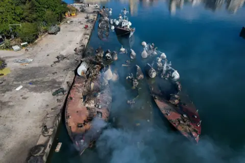
Israeli warplanes reportedly carried out hundreds of airstrikes across Syria, targeting Syrian army military installations, including weapons depots, ammunition depots, airports, naval bases, and research centers.
The UK-based Syrian Observatory for Human Rights says it has documented more than 300 raids launched by Israel since the fall of the Assad regime on Sunday, including on the capital, Damascus, Aleppo and Hama.
Reports indicate that many of the affected facilities have been completely destroyed.
Israel says its moves are aimed at preventing weapons from falling “into the hands of extremists” as Syria moves into the post-Assad era.
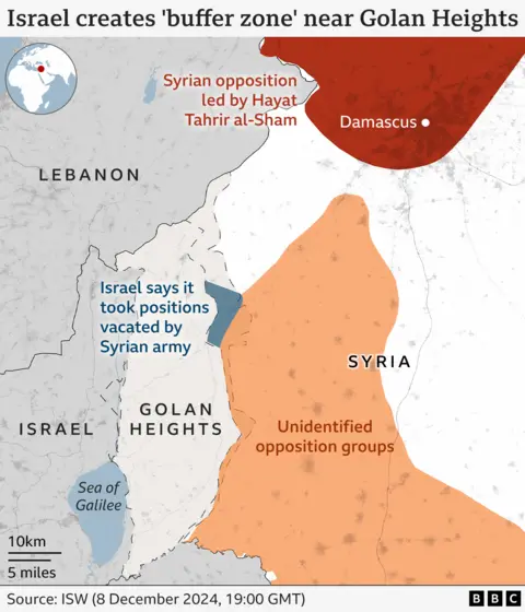
Israel also says it did so Control temporarily Israel announced the establishment of a demilitarized buffer zone in the Golan Heights, saying that the 1974 disengagement agreement with Syria had “collapsed” with the rebels taking control of the country.
It denies reports that its tanks are approaching Damascus, but says that some forces are operating in Syrian territory outside the buffer zone.
The Golan Heights is a rocky plateau about 60 kilometers (40 miles) southwest of Damascus.
Israel seized Syrian territory in the final stages of the Six-Day War in 1967 and annexed it unilaterally in 1981. The move was not recognized internationally, although the United States did so unilaterally in 2019.
What is happening in northern Syria?
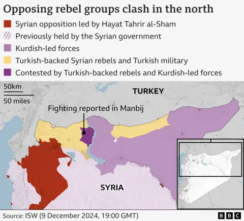
Clashes broke out in the northern city of Manbij between Turkish-backed forces and Kurdish-led rebels.
Both sides claimed to have taken control of parts of the city, and fighting was reported to be continuing in some neighbourhoods.
Analysts at the Institute for the Study of War said they were not yet able to confirm who controls Manbij.
Russian bases in Syria
In 2015, Russia sent thousands of troops to Syria to help keep President Assad in power.
In exchange for this military assistance, Russia was granted 49-year leases on two major military bases.
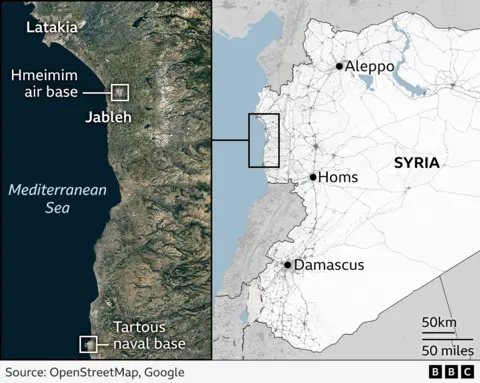
The port of Tartus is Russia's only major naval base abroad and also its only naval base in the Mediterranean.
Along with the air base at Hmeimim, which is often used to transport Russian military contractors to Africa and beyond, the two bases play an important role in Russia's ability to act as a global power.
The Kremlin said it would hold discussions with the new Syrian administration regarding the future of both sites.
 Getty Images


